Open Access: A citizen’s guide to uncovering housing and local information
Our community-driven platform Noteworthy helps you find out if you are in an area prone to floods, landslides, high radon and more.


THE KEY TO making good decisions is having access to good information. The team at Noteworthy, the community-led investigative platform from TheJournal, presents this four-part series which aims to give YOU the power to access data from public authorities on matters that impact on your life.
Today, we look at publicly available information on housing and your local area.
In this series we’ve covered how to access public and personal records through various mechanisms including the Freedom of Information (FOI) Act, Access to Information on the Environment (AIE) and GDPR.
However, there is a lot of information you can access in Ireland without any forms or requests. These records won’t be personal to you but they can be relevant to your local area or house.
By the time you finish reading this article, you should be able to tell if you are in an area prone to floods, landslides, air pollution or high radon, and what plans are afoot in your locality.
- Noteworthy is a crowdfunded platform. You might consider supporting more of our work with a contribution to our general fund.
How Noteworthy uses publicly available information
Before we submit any FOI or AIE requests as part of our investigations, we always look to see if the information we are seeking is already in the public domain. This can be the case with plans, reports or other data we are looking for.
For example, our Selling Our Genes investigation in collaboration with the Business Post found hospitals and universities across Ireland collaborating with a private DNA sequencing company – Genuity Science.
Most of this information was sourced through extensive online searches. Though these documents were mostly publicly available, no journalism team had compiled and analysed them previously.
Related to biodiversity, Noteworthy reporter Niall Sargent analysed online forestry databases in his recent Spruced Up investigation which found that licences for conifer plantations were still being granted on biodiversity-rich areas and precious peat soils.
Open sources used as part of this work included minutes from working groups and steering groups, information on forestry licences and Forestry Appeals Committee decisions.
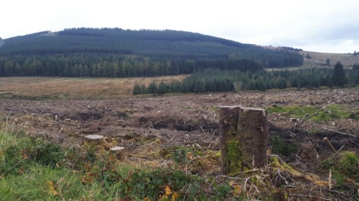 Plantation site after clearfell in the Wicklow Mountains
How you can find housing-related information
Though online searches can bring up a lot of information, it is useful to know the right links and databases as it’s not always obvious where to look or what is available online.
Here’s a quick overview:
Planning
You can view upcoming as well as previous planning applications for your local area, often both in list and map form. Links to your local council planning database can be found here.
You can search using your street to see what your neighbours are planning to build or widen out the search to your local area to find out more about local developments.
This can also be a very useful database if you are planning an extension or building work yourself as you can read the decisions the council gave in your local area and adapt your plans to suit.
The planning application could also be going through An Bord Pleanala if it is a large housing development in the fast-track process or if it is being appealed. You can search and view these cases here, though they are far easier to find on the site if you know the case number.
Floods
With floods across the country in recent years – and an increasing number predicted due to climate change – one site that is essential to review when buying any property is Floodinfo.ie which details past, present and predicted flood maps.
This resource was created by the Office of Public Works (OPW) who “assessed and mapped the flood extents, hazard and risk for a range of flood events from frequent, minor flood events up to very rare, extreme events”.
The default map shows the extent of river and coastal flooding but if you go to the ‘Layers’ icon, you can view past flood events as well as the extent of predicted future flooding.
This can be viewed at a street level so you can find out if your house – or intended purchase - was under water last winter or will be in the future.
Noteworthy undertook an investigation earlier this year into the planned flood scheme in Cork City so lets use the southern capital as an example. Below is a screenshot of the extent of present day river and coastal flooding as well as a mid-range future scenario of flooding for the city.
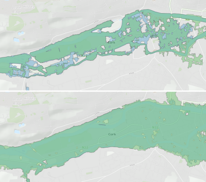 Present (above) and mid-range future scenario (below) of river and coastal flooding in Cork City.
Other risks
In addition to flooding, maps and other databases are also available online for a number of other risks:
Water Quality – If you are connected to a public water supply, you can search the water quality in your area with your address or postcode here. You can also view all of the water alerts around Ireland on a map. These include times when there may be disruptions to the water supply as well as ‘Boil Water’ and ‘Do Not Drink’ alerts.
- The Noteworthy team wants to find out where in Ireland has the most polluted tap water. Find out more about this project.
Radon – This cancer-causing radioactive gas linked to 300 lung cancer cases each year in Ireland – the second largest cause after smoking – with one-third of the country classified as a high radon area by the Environmental Protection Agency (EPA). You can use this map to find out if you are in a high radon area.
- This week, we launched a proposed investigation to investigate if the State is doing enough to protect families from this cancer-causing dangerous gas. Support this work here.
Landslides – With large landslides in Leitrim and Donegal in recent months, you might want to know if you live in an area where landslides have occured or might do in the future. You can do this using National Landslide Susceptibility Map by Geological Survey Ireland.
Air pollution – A recent EPA report found that air quality in some urban areas in Ireland doesn’t meet WHO standards. Local monitoring stations can be viewed on airquality.ie and gives detail of readings taken recently and over the past few months.
Development
Developments can be welcomed or cause controversy in a local area. Two types of development fall into the latter category in many parts of rural Ireland – wind farms and forestry.
Wind farms - Planned wind farms or those going through the planning process can be found on your council’s planning database, but those in operation can be viewed on the Wind Atlas. This is a map of Ireland’s wind energy resources which is run by the Sustainable Energy Authority of Ireland (SEAI). It also displays wind speeds around Ireland.
- Related to this, we are hoping to investigate the impact of wind farms on local communities. Read more about this here.
Forestry – In our recent Spruced Up investigation mentioned earlier, we found that forestry information is available online, but in some instances this can be hard to pinpoint to local areas unless you know the exact address. Here are a few links that may help:
- Licences: Licence Applications for felling, afforestation, forest roads and aerial fertilisation can be found here. A new Forestry License Viewer was released by the Department of Agriculture at the start of the month. As part of our investigation, we compiled afforestation licence applications from 2010 to August 2020 in this searchable table.
- Appeals: Forestry Appeals Committee (FAC) decisions can be found here. In a Noteworthy article out this morning which reveals serious concerns remain over environmental assessments, we compiled FAC cases up to December in a searchable table:
Development Plans - Another big source of information on your locality are Development Plans and Local Area Plans which you can find by searching for them on your council’s website. Minutes of local council meetings – normally available on your council website – can also be useful to find out the latest information on developments.
Zoning – Is your area zoned as residential, mixed, amenity, industrial or another category? You can find out on the Department of Local Government’s Zoning Map Viewer.
Information available to the public
These are just some of the Irish online datasets and maps but there are plenty of others that you can search for.
For instance on the topic of health, you can view all of the Health Information and Quality Authority (HIQA) inspection reports on your local hospitals or nursing homes.
One last depository of information worth mentioning is Oireachtas.ie for both local and national topics of interest as they may have been the subject of a debate or parliamentary question.
- If you found this guide to accessing information useful, you might consider supporting more of Noteworthy’s work with a contribution to our general fund.
- You can also submit ideas for investigations or stories you would like us to cover here.